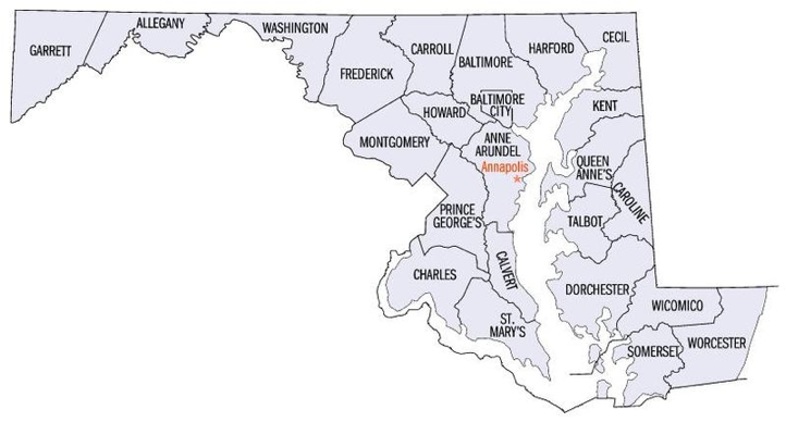
Kent County, Maryland
Map of Maryland showing Kent County where this Elburn family lived.
Kent County, Maryland, showing the 7 districts, named after the English
County of Kent in 1642.
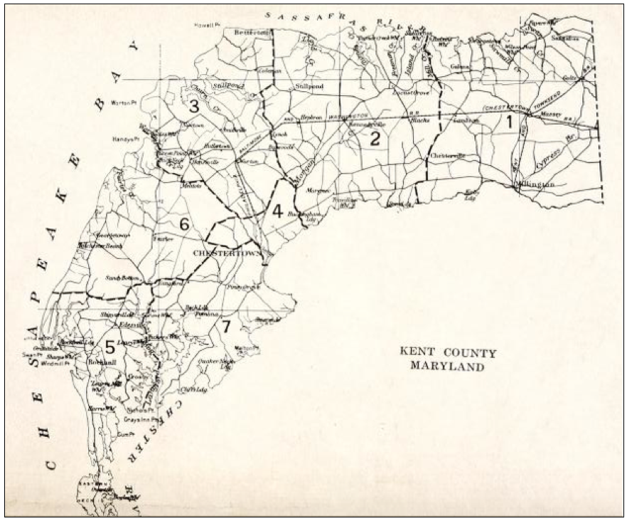
From the map of Kent County, Maryland shown above, for the 1800’s only: Kent County is divided into 5 districts which are mentioned in the census records. These districts tell us a lot about which family lived where. For example, District 1 is closest to the state of Delaware and this is where my husband’s family came from, who eventually moved to Ohio. Just west of District 1 is District 2, then District 3 runs along the Chesapeake Bay. District 4 covers the entire southerly peak of Kent County and this is where Samuel Elburn and his descendants resided near Rock Hall. District 5 runs along the southeast part of Kent County and borders Queen Anne’s County.
By the 1900’s, these districts were divided into more districts, boundaries changed, and renamed. The names in bold are where the Elbon families lived.
District 1 became the District of Massey with Sassafras, Golts, Massey, Georgetown, Galena, Chesterville, Millington, Lambson
District 2 became the District of Kennedyville with Locust Grove, Kenmore Park, Stillpond, Hepbron, Lynch, Bigwoods, Morgnec
District 3 became the District of Worton with Betterton, Newtown, Smithville, Butlertown, Honesville, Worton, Milifoto
District 4 became the District of Chestertown with Chestertown.
District 5 became the District of Edesville with Rock Hall, Crosby, and Edesville.
District 6 became the District of Fairlee with Georgetown, Fairlee, Sandy Bottom, and Tolchester.
District 7 became the District of Pomona with Longford and Pomona. New District 2 is Kennedy with Stillpond, Bigwoods, Lynch, Hepbron, and Kennedyville.
Map of Delaware and Maryland in 1775
![Description: [DE DIVIDE]](MapofMaryland_files/image006.png)
The
Delaware-Maryland Divide and
Hundreds Boundaries 1775-1830
The boundary between
Delaware and Maryland was originally set to be the line dividing rainfall that
flowed into the Chesapeake Bay from rainfall that flowed into the Delaware
River and Bay. This MD-DE Divide is shown as a broad serpentine line on the map
above.
Travel in the 1700s
was primarily by water, so the people who settled west of the MD-DE Divide came
primarily from either direct immigration through an Eastern shore Maryland port
or moved from what is now Maryland while those who settled east of the MD-DE
Divide, especially in New Castle and Kent counties, came primarily from direct
immigration through a Delaware port or moved from Pennsylvania and New Jersey.
Before 1764, when a
team of British surveyors led by Mason and Dixon set the western and southern
borders for Delaware, deeds for land in the shaded area of the map below [* Yes
we need a new map here, since the shading is not present in the image below *]
were often granted by Maryland, which claimed all of present Delaware as
"Durham Co."
The borders of the
Delaware hundreds (see the page on Delaware's Hundreds) as they
had evolved by 1775 remained unchanged until 1830, but they were sometimes
designated by more than one name; for example. Dover
Hundred was also called St. Jones Hundred and Broadkill
Hundred was also called Broadkiln Hundred.
CREDITS: The
"Delaware Divide" map appears on page 51 of the Delaware Genealogical
Research Guide - 2nd edition (1997) and was taken from the Delaware Geological
Survey (Newark DE). The shaded area for Maryland deeds was
designated by George L. Caley, and the
dashed-line boundaries for hundreds and counties were added by Thomas P. Doherty.
See http://delgensoc.org/dedivide.htm.